 |
| River Indus |
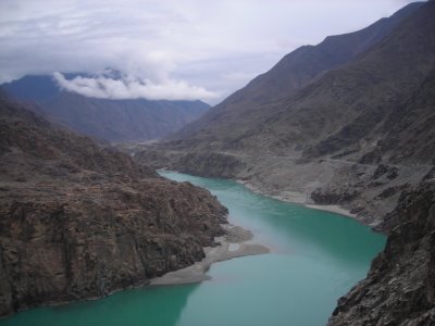
The Indus, Siran, Dor, Harroh & kunhar are the important water resources in Hazara. Here it is also worth-mentioning that the Indus river, after covering its course through Kohistan Area, and the River Jehlum, only skirts this division. The Former runs on the western side of Hazara for 30 miles while the later on the Eastern side for 25 miles.
 |
| Beauty of River Indus |
The Rivers and streams mentioned above differ from one another in respect of their origins and discharge flow. The Indus rises about 280 miles away from Ladakh, while the Siran, Dor & Harroh takes start from Bhogarmang valley. Dunga Galli (near Nathia Galli) and Lalu Sar Lake (Naran Valley) respectively.
Irrigation in this region is possible mainly by the Siran, Dor and Harroh, while the Kunhar, which joins the River Jehlum at Domail, is so rapid and deep that utilization of its water for irrigation on a large scale is very difficult.
 |
| River Kunhar in its bloom |
The above mentioned water bodies have numerous tributaries. Among them some are perennial while others seasonal. These in the Vernacular are known Kathas, or small torrents. These Kathas are an important source of irrigation and water more then 22000 acre of land under their respective catchment limits, while Siran, Dor and Harroh irrigate some 20,000, 16,000 and 5000 acre of land respectively.
LAKES:
 |
| Ansu Lake (TEAR) |
There are many natural, as well as, man made lakes in Hazara. These , surrounded by rocky snow capped hills are confined to the Kaghan Valley and Haripur District. Their names are Lalu Sar, Dudi Pat Sar, Saif ul Malook, Ansoo (Tear) Tarbela and Khanpur Lake.
 |
| Tarbela Lake |
These Lakes lies in Idyllic seclusion and tranquil surrounding with their water reflecting the wonderful and changing tints of the sky. There are associated many fables, and events of great importance with these lakes, such as, the Legendary Love story of one fairy named BADAL JAMAL connected with Lord Saif ul Malook Sar and the scene of arrest of some 600 soldiers of 55 native infantry in 1858 are connected with Dudi pat Sar.
 |
| Saif-ul-Malook |
Besides, there also exists a large area in the Division where water is scarce or distant. In these areas, especially in the Tanawal Region and District Haripur, ponds for storage of rain water have been constructed and people utilize their water for drinking and irrigation purpose, from the same tanks.
MINES & MINERALS:
Though mining in Hazara has not been done on a large scale but minerals of different kinds like Coal, Lime Stone, Building stone, Gypsum, Coarse Slate, Antimony or oxide of led (Surma, Kajal) and iron are founded in abundance in this area.


